With the opening of the Morganza Spillway beginning today,
low lying areas in Terrebonne Parish are almost certainly going to go under water. This includes Gibson, Bayou Black where several swamp tours operate, Southdown Mandalay, and Bull Run Road where our USDA Farm is located. Beyond this, it is a wide open question as to how serious flooding will get in Terrebonne Parish as shown by the Army Corps of Engineers map at left. We are being assured by government officials that Houma should remain dry, but we all too keenly remember how levees didn't hold up in New Orleans during Hurricane Katrina. It is not outside the realm of possibility that the
Mississippi River could change course under a massive flooding situation, changing to the more direct and steeper flow through the Atchafalaya River to Morgan City, which is where it used to primarily flow, going back enough years. Obviously, this would be catastrophic to all of the coastal Parishes in Southeastern Louisiana. Peak flooding is expected in this area around May 23, a little over a week from now.
 During the final five weeks of my employment at the USDA Sugarcane Research Unit, following our move to Tennessee, I have been staying with Greg and Monica Stock who live in Thibodaux, LA. Since they live only 25 miles from the famed Oak Alley Plantation near Vacherie, LA along the Mississippi River, I decided to take a leisurely Sunday afternoon drive to see what the river looked like at flood stage. For southern Louisiana, the day couldn't have been more perfect, weather wise, with lots of sunshine, relatively low humidity, and pleasant temperatures.
  There wasn't a large crowd of people trying to see the river at the front of Oak Alley as I had expected, yet while I was there for about 20 minutes, several people pulled over with the express purpose of ascending the 20-ft levee to see the river, as I had done. My strongest impression of the river was that it was flowing very fast, much like any large river would do going through a narrow strait. During the entire time I was on top of the levee, I saw no river traffic. I could see barges on the other side of the river that were tied down. Of course it is always a funny feeling to see how much higher the river is than the land it is passing by, including the Oak Alley Plantation itself.
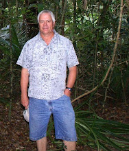
  The three photos I included show the Oak Alley Plantation; then looking in the opposite direction, the river, and finally, a photo of me taken by some onlookers. My only other significant observation on this trip was how the sugarcane is starting to really show stress effects from the severe drought we are going through in southern Louisiana. It is indeed ironic that we are going through a severe drought while simultaneously experiencing flooding from the Mississippi River.